Ke Bang – limestone largest Indochinese peninsula
Famous geographer Le Ba Thao had assessed this rocky massif to 10,000 km2 wide, lies perched atop the CTS, which borders Vietnam
Famous geographer Le Ba Thao had assessed this rocky massif to 10,000 km2 wide, lies perched atop the CTS, which borders Vietnam – Laos cut through. Part of Vietnam, where the world heritage Phong Nha – Ke Bang, only accounted for less than half, the rest of Laos.
This huge limestone blocks still wild, almost no point of human colonization. There is no way even the trail. The study of geology or forestry mainly made on aerial photographs and satellite imagery. Nor is there any rivers or streams show his face, no significant ground. Nearly ten thousand square kilometers cat ears jagged rocks, along the edge only appear small stream valleys surrounded by steep cliffs. The average elevation of 800 meters massif is, sometimes rising above the thousand-meter high mountain, the highest peak Phu Et Va (1.512m).
Limestone massif geological age Ke Bang from 380 million to 240 million years. Over many geological changes, rocks cracked, cracks, enabling intrusion of water, dissolved into various forms karst topography: valleys, funnels, wells, karst pits, underground caves dry or there is water enough sizes. Ke Bang region has considerable rainfall, 3,000 mm per year. Much of this water into the underground caves, which Phong Nha is one that countless caves.
Near the Phong Nha cave entrance, the geologists have found fossilized woody vegetation, terrestrial vegetation of the first team in the history of the earth is called Vegetable Lo ceiling (Psylophyta) and plant scales trees (Lepidophyta). The terrestrial vegetation types shows once existed a very ancient continent that Ke Bang limestone formations are located in suburban transgression continent. Can see the imprint of the fringe creating images that continent through the thick limestone layer of cubic meters to 4,000 Ke Bang, like a mattress giant stones, rocks overlying volcanic island arc type (like the Japanese archipelago and the Philippines today).
Many scientists have long suspected that the continents on a fragment of the Australian continent, was drifting north. The evidence for that theory is in the area of Dat, Minh Hoa district, Quang Binh, in the 1980s, scientists have discovered that a species of fossil Hand roll Australia 30 million years old. That Veervesia suchana species, has her home in northwest Australia Fitzoy region.
In addition to the value of geology, national park of Phong Nha – Ke Bang also has populations of animals and plants are preserved quite well that many other areas have little or no longer meet again. Due to the nature of tropical forest on limestone, so there are many unusual species, rare, as cheesy density, needle, frankincense, tree ferns, coolie, gaur, wild cats , java mouse-deer … some places in the garden there are hundreds of acres of extensive forests only a few species such as domesticated flower slice, slice the skin contract. Here also can meet hundreds of golden monkeys or snakes breeding season, you can see hundreds of black snake wrapped braided together in the narrow limestone cavity …
In a few stones in Phong Nha cave chamber, also met relics of temples with carved in stone writings by ancient Cham. This certainly is not the only evidence of ancient human in this land, because the world in the Ke Bang caves have not been explored before.
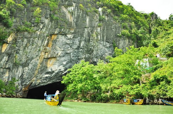
Famous scenic Phong Nha Cave is actually composed of two lines: dry (King’s Castle) and dynamic wet (Thuy Tien Qi). Dynamic is considered the best 7: longest water cave, highest and widest entrance, wide sandy beaches and rocks, and the most beautiful, the most beautiful underground lakes, majestic stalactites and the virtual, the longest underground river Vietnam (13.969m) and the largest and most beautiful dry cave. Phong Nha own by forming an underground river, there are several sections of the lake and extensive mudflats. The main chamber consists of 14 connected by a long hallway to 1.500m. The whole dynamic is 800-900 m deep under the mountain.
BBT


