Scientific research and technological application is an important solution of all activities in social life and development process. Recognizing the importance of applying technology in the management, conservation and promotion of Phong Nha – Ke Bang National Park World Heritage, the Park’s research team has participated in many scientific research projects at the provincial level, especially the registration of Quang Binh Technology Creativity Contest and achieved remarkable results.
In many years, scientific research in Phong Nha – Ke Bang has achieved significant results, step by step testing and applying technology in resource management. The Park’s research team has participated in many scientific research projects at the provincial level, especially the registration of Quang Binh Technology Creativity Contest. The contest is held every two years to promote the movement of technical innovations, emulate and apply technological advances into production. Science and technology have become an important resource for socio-economic development and environmental protection.
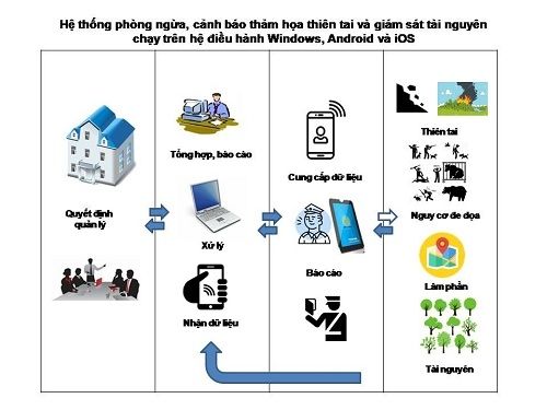
At the 7th Quang Binh Technology Creativity Contest (2016-2017), the research team of Phong Nha – Ke Bang National Park Management Board has got a consolation prize with solution “Application of GIS techniques and remote sensing running on Windows, Android and iOS in disaster prevention, warning and resource monitoring systems.” This is an integrated analysis system based on GIS and remote sensing that is analyzed and processed on Argis 10x, ENVI, property data is converted to *. cmf, run by Carrymap application on Android, Windows, iOS smartphone display and * .kml, * .kmz file format shown on Google Earth. The system uses CarryMap software to open digital maps interacting with functions on the device (GPS positioning) to locate, save coordinates and overlap with google earth software to locate quickly, accurately.
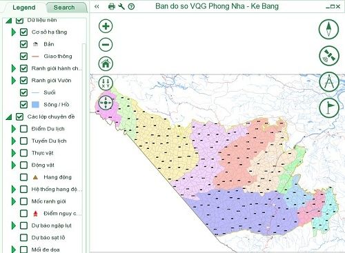
Application of GIS techniques and remote sensing is a high-tech field which is highly effective in many fields, especially in building and providing spatial information infrastructure in monitoring of natural resources and the environment. At the 6th Quang Binh Technology Creativity Contest (2015-2016), the research team has got the third prize with the solution “Electronic Atlas of Phong Nha – Ke Bang” and and awarded by the Vietnam General Confederation of Labor in 2016.
With these accomplishments and results achieved in the field of scientific research, it is hoped that scientific research activities will contribute significantly to the renewal and improvement of operational effectiveness in management and conservation and and exploit effectively values of World Natural Heritage Phong Nha – Ke Bang National Park in the next time./.
My Hanh


